Drone Maps and Smart Irrigation: The Future of Precision Agriculture
Agriculture is undergoing a digital transformation. With climate uncertainty, water scarcity, and rising production costs, farmers and agricultural planners are increasingly relying on data-driven decision-making to optimize resources. Among the many innovations shaping modern agriculture, irrigation zone mapping using drone data has emerged as one of the most powerful tools for improving water management and crop productivity.
However, one challenge remains: access to high-quality drone mapping data. Not every agricultural organization, irrigation consultant, or research institution has the ability to conduct drone surveys themselves.
This is where platforms like Drone Map Market, developed by GISFY, are changing the landscape by connecting drone data creators with organizations that need high-quality geospatial data.
What is Irrigation Zone Mapping?
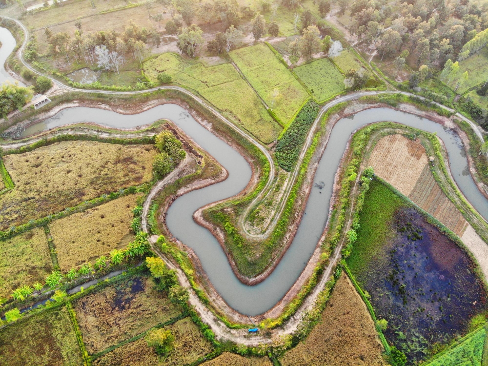
Irrigation zone mapping is the process of dividing agricultural land into specific zones based on soil conditions, crop health, moisture levels, elevation, and drainage patterns. Each zone can then receive a different irrigation schedule or water quantity tailored to its needs.
Traditionally, irrigation planning relied on:
-
Manual field inspections
-
Soil sampling
-
Satellite imagery with limited resolution
While useful, these methods often lack the precision needed for modern agriculture.
Drone mapping solves this problem by capturing high-resolution aerial imagery and geospatial data, enabling detailed analysis of farmland conditions.
With drone-generated maps, farmers and agronomists can identify:
-
Over-irrigated areas
-
Water-stressed crops
-
Soil moisture variation
-
Drainage issues
-
Uneven crop growth patterns
These insights help implement precision irrigation strategies that reduce water waste and increase yield.
The Growing Demand for Drone Mapping Data in Agriculture
The global drone GIS mapping industry is expanding rapidly as industries adopt drone-generated spatial data for decision-making. The market was valued at around $349.5 million in 2023 and is projected to reach about $1.87 billion by 2034, driven by demand across agriculture, infrastructure, and environmental monitoring.
Agriculture is one of the biggest drivers of this growth because precision farming requires accurate, localized spatial data.
Drone-based irrigation zone mapping enables stakeholders such as:
-
Agri-consulting firms
-
Irrigation equipment companies
-
Agricultural universities
-
Government water management agencies
-
Smart farming startups
to make better decisions about water distribution.
But many of these organizations face a common problem:
Obtaining drone mapping data quickly and affordably.
The Hidden Value of Drone Mapping Data
Drone operators around the world capture vast amounts of aerial data during mapping missions, orthomosaics, elevation models, vegetation maps, and irrigation analysis datasets.
However, much of this data is used only once for a project and then stored away on hard drives. In the drone mapping community, professionals often highlight that valuable datasets remain unused despite being relevant for many industries such as agriculture, construction, or environmental monitoring.
This creates a missed opportunity.
A drone survey conducted for one agricultural project might contain valuable information that could help:
-
irrigation planners
-
researchers studying soil moisture
-
agri-tech startups developing irrigation models
-
farmers planning water infrastructure
Instead of conducting new expensive drone surveys, these stakeholders could benefit from existing datasets if they could easily find them.
Introducing the Drone Map Market
This is the problem that Drone Map Market aims to solve.
The platform functions as a marketplace for drone mapping data, connecting two key groups:
1. Drone Data Sellers
-
Drone pilots
-
UAV survey companies
-
Mapping professionals
-
Geospatial service providers
2. Drone Data Buyers
-
Agriculture consultants
-
Irrigation planners
-
engineering firms
-
researchers and analysts
Through this marketplace, sellers can upload and list high-resolution geo-referenced drone maps, while buyers can explore datasets across industries including agriculture, infrastructure, and environmental monitoring.
This creates a global ecosystem for drone mapping data exchange.
How the Drone Map Market Supports Irrigation Zone Mapping
For irrigation planning, access to accurate drone maps is critical. Drone Map Market allows buyers to discover datasets that can support irrigation zone mapping workflows.
Typical drone datasets available on such platforms may include:
1. Orthomosaic Maps
High-resolution stitched aerial imagery that provides a detailed view of crop patterns and irrigation lines.
2. NDVI Vegetation Maps
Used to identify crop stress caused by poor irrigation or soil moisture variation.
3. Digital Elevation Models (DEM)
These models help detect water flow direction and drainage patterns, which are essential for irrigation planning.
4. Soil Moisture and Field Variability Maps
Used to divide farmland into efficient irrigation zones.
With these datasets, agricultural planners can quickly perform irrigation analysis without waiting weeks for new drone surveys.
Benefits for Drone Data Sellers
Drone pilots and mapping companies often operate in competitive markets where revenue depends on new projects.
By listing datasets on Drone Map Market, sellers can unlock new revenue streams.
Key benefits include:
-
Monetizing previously unused drone mapping datasets
-
Reaching global buyers looking for specialized mapping data
-
Managing map listings, metadata, and pricing through the platform
-
Uploading multiple maps and showcasing their work to potential clients
In essence, a drone map becomes a digital asset that can generate value beyond the original project.
Benefits for Data Buyers
For organizations involved in irrigation zone mapping, the marketplace model provides several advantages.
Faster Access to Data
Instead of commissioning new drone surveys, buyers can access ready-to-use datasets.
Cost Efficiency
Drone surveys can be expensive, especially across large agricultural regions. Accessing existing data significantly reduces costs.
Global Coverage
Buyers can discover drone datasets from different geographic regions, enabling comparative analysis or regional planning.
Direct Communication
The platform allows buyers to connect directly with data creators to discuss project requirements or custom data needs.
Why Platforms Like Drone Map Market Matter
As agriculture moves toward precision irrigation and smart farming, data accessibility will become increasingly important.
Farmers and agri-tech companies no longer need just satellite imagery; they require high-resolution, localized drone datasets.
At the same time, drone pilots and mapping companies generate massive volumes of geospatial data.
Platforms like Drone Map Market bridge this gap by creating a central marketplace where drone mapping data can be discovered, shared, and monetized.
This model benefits the entire ecosystem:
-
Drone operators generate additional income
-
Agricultural companies access better data
-
Researchers gain valuable datasets
-
Governments and planners improve irrigation policies
The Future of Irrigation Zone Mapping
In the coming decade, irrigation planning will increasingly rely on AI-driven analytics, drone imagery, and geospatial intelligence.
With rising global pressure on water resources, precision irrigation technologies will become essential to ensure food security.
Drone mapping data will play a crucial role in enabling:
-
Smart irrigation systems
-
automated crop monitoring
-
water optimization models
-
climate-resilient agriculture
However, the success of these technologies depends on easy access to reliable spatial data.
Join the Drone Map Market Ecosystem
Drone surveying has already transformed how industries collect spatial data. But the next evolution of this technology lies in how that data is shared and utilized.
By connecting drone data sellers with data buyers, Drone Map Market is building a global ecosystem where drone mapping datasets can create value far beyond their original projects.
Whether you are:
-
a drone pilot with valuable mapping data, or
-
an organization searching for high-quality drone survey datasets,
Drone Map Market provides a platform where geospatial data meets opportunity.
Register today: https://www.dronemapmarket.com/register/buyer
and become part of the growing global network where drone surveying data powers smarter decisions across industries. 🚁📊
