The Science of Soil Variability Mapping with Drone Technology
Agriculture today is no longer driven purely by experience and traditional farming practices. Modern agriculture relies on data-driven insights, especially when it comes to soil management. One of the most important technologies helping farmers and agricultural planners make better decisions is soil variability mapping.
However, while the value of soil mapping is widely recognized, access to high-quality geospatial drone data remains a major challenge for many organizations.
This is where Drone Map Market plays a transformative role. By connecting drone data sellers and drone data buyers in a single marketplace, the platform developed by GISFY is enabling faster access to valuable drone mapping datasets that can support soil variability analysis across agricultural landscapes.
Understanding Soil Variability Mapping
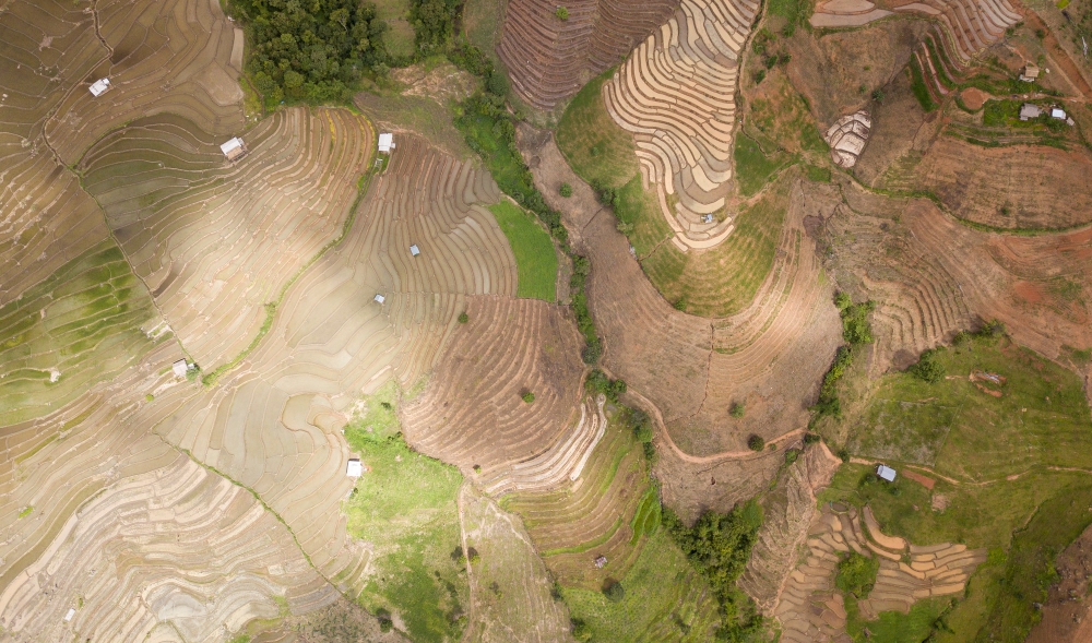
Soil variability mapping refers to the process of analyzing differences in soil properties across different parts of a field. Even within a single agricultural plot, soil conditions can vary significantly due to factors such as:
-
Soil texture
-
Organic matter content
-
Nutrient distribution
-
Moisture retention
-
Elevation and drainage
These variations affect crop performance, fertilizer efficiency, and irrigation planning.
Without accurate soil variability maps, farmers often apply uniform inputs across entire fields, which leads to:
-
Overuse of fertilizers
-
Inefficient irrigation
-
Reduced crop productivity
-
Increased environmental impact
Soil variability mapping helps identify precise zones within a field, enabling farmers to implement precision agriculture practices.
Why Drone Mapping is Essential for Soil Variability Analysis
Traditional soil analysis relies on manual sampling and satellite imagery. While useful, these approaches often lack the resolution and accuracy needed for detailed field-level insights.
Drone mapping changes this by providing high-resolution aerial data captured at low altitudes, allowing for precise soil and crop analysis.
Drone-generated datasets can produce:
-
Orthomosaic maps of farmland
-
Digital Elevation Models (DEM)
-
Vegetation health indices such as NDVI
-
Moisture pattern maps
These layers reveal subtle patterns that indicate soil variability.
However, conducting drone surveys across large agricultural regions can be time-consuming and expensive, especially for organizations that do not operate drones themselves.
The Untapped Value of Drone Mapping Data
Across the world, thousands of drone pilots conduct aerial surveys for industries such as agriculture, construction, mining, and environmental monitoring.
After completing a project, the captured mapping data often sits unused in storage systems. Many professionals in the UAV mapping community note that valuable datasets frequently remain archived even though they could benefit other industries or research applications.
This creates a huge missed opportunity.
A drone survey originally captured for one agricultural project may contain valuable insights about soil patterns, terrain elevation, or crop health that could help:
-
agricultural consultants
-
irrigation planners
-
agri-tech startups
-
soil scientists
-
researchers
The challenge is discoverability finding these datasets and connecting with the people who created them.
Introducing Drone Map Market
Drone Map Market was created to solve exactly this problem.
The platform functions as a global marketplace for drone mapping data, where:
-
Drone map creators can upload and sell high-resolution geo-referenced maps
-
Organizations can browse, connect with sellers, and obtain the data they need
Instead of commissioning a new drone survey every time, data buyers can discover existing datasets that match their needs.
At the same time, drone operators gain an opportunity to monetize their previously captured mapping data.
How Drone Map Market Enables Soil Variability Mapping
For professionals working in agriculture and soil analysis, the availability of drone data is critical.
Through Drone Map Market, buyers can discover datasets that help analyze soil variability, such as:
1. High-Resolution Orthomosaic Maps
These stitched aerial images provide detailed visual information about crop growth patterns and soil exposure.
2. Elevation and Terrain Models
Digital Elevation Models help detect subtle terrain variations that influence water flow and soil moisture.
3. Vegetation Health Data
Indices like NDVI reveal crop stress areas that may correlate with poor soil conditions.
4. Field Variability Maps
Drone imagery helps identify zones where soil nutrients or moisture differ significantly.
Using these datasets, agricultural professionals can create precision farming strategies, including:
-
Variable-rate fertilizer application
-
Optimized irrigation systems
-
Targeted soil treatment programs
Benefits for Drone Data Sellers
Drone pilots and mapping companies constantly generate valuable datasets, but often these are used only once.
Drone Map Market allows them to transform their data into long-term digital assets.
Key benefits include:
-
Uploading and listing high-resolution drone maps
-
Setting custom prices for datasets
-
Reaching a global network of buyers
-
Managing map listings and metadata through the platform
Sellers can choose different subscription plans depending on how many maps they want to list and how much exposure they want in the marketplace.
In essence, every drone mission has the potential to generate ongoing revenue beyond the original project.
Benefits for Data Buyers
For organizations that need soil variability mapping data, the marketplace model offers several advantages.
Faster Data Access
Instead of organizing new surveys, buyers can access existing drone datasets immediately.
Cost Efficiency
Conducting drone surveys can be expensive. Accessing already captured data significantly reduces costs.
Global Dataset Availability
Buyers can explore drone mapping datasets from different regions around the world.
Direct Collaboration with Data Creators
Buyers can connect directly with sellers to discuss dataset specifications, formats, and custom requirements.
Why Data Marketplaces Are the Future of Drone Mapping
The global drone industry continues to expand rapidly, with thousands of companies operating across hardware, software, and drone services worldwide.
As drone usage grows, the amount of geospatial data being generated will increase exponentially.
This makes data marketplaces like Drone Map Market extremely important.
They help create a centralized ecosystem where drone-generated spatial data can be discovered, shared, and monetized.
For agriculture and soil science, this means:
-
Better access to geospatial intelligence
-
Faster research and analysis
-
Improved precision agriculture practices
-
More efficient resource management
The Future of Soil Variability Mapping
In the coming years, soil variability mapping will become even more powerful as it integrates with technologies such as:
-
Artificial intelligence
-
machine learning-based crop analysis
-
IoT soil sensors
-
automated irrigation systems
Drone data will remain one of the most valuable sources of high-resolution agricultural intelligence.
However, the ability to access the right data quickly will determine how effectively these technologies are used.
That is why platforms like Drone Map Market are becoming increasingly important.
Join the Drone Map Market Ecosystem
Drone surveying has already transformed how industries collect spatial data. But the next evolution of this technology lies in how that data is shared and utilized.
By connecting drone data sellers with data buyers, Drone Map Market is building a global ecosystem where drone mapping datasets can create value far beyond their original projects.
Whether you are:
-
a drone pilot with valuable mapping data, or
-
an organization searching for high-quality drone survey datasets,
Drone Map Market provides a platform where geospatial data meets opportunity.
Register today: https://www.dronemapmarket.com/register/buyer
and become part of the growing global network where drone surveying data powers smarter decisions across industries. 🚁📊
