Solar Farm Thermal Mapping: How Drone Map Market Turns Hidden Panel Failures into Instant Revenue and Efficiency Wins
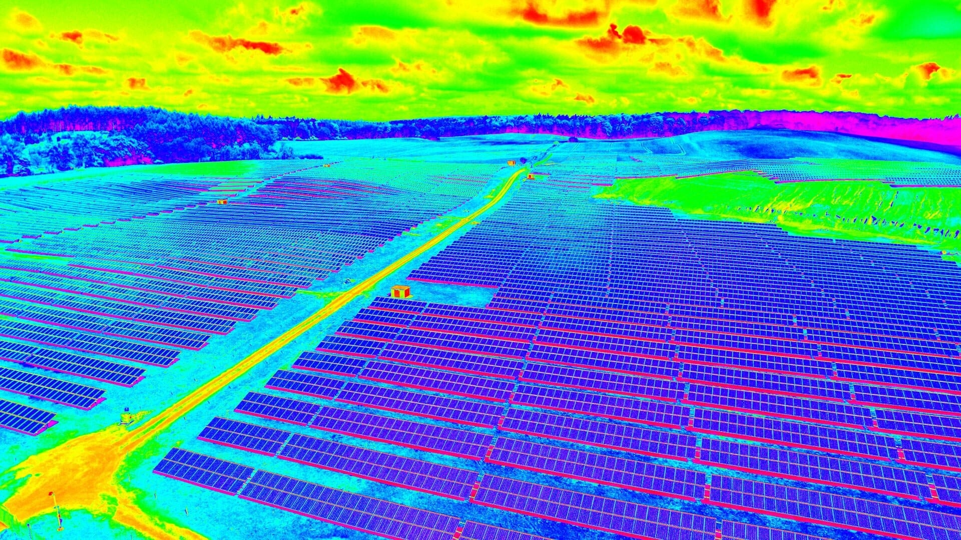
Picture a 50-megawatt solar farm baking under the midday sun. Rows of panels stretch to the horizon, quietly generating clean energy until invisible hot spots, cracked cells, or dust buildup start slashing output by 20% or more. One faulty string can cost thousands in lost generation every single month. Traditional ground inspections miss the big picture. Helicopter flyovers are expensive and weather-dependent. Now imagine pulling up a high-resolution thermal map of the entire array in minutes: every overheating module flagged in vivid color, precise GPS-tagged, ready to import into your O&M software. No new drone flight required. This is solar farm thermal mapping and it’s the fastest, safest way to maximize uptime, extend panel life, and protect your ROI.
The challenge? Not every solar developer or operations team owns a thermal-equipped drone fleet or the processing expertise to turn raw infrared data into actionable intelligence. Professional drone pilots and surveying firms capture terabytes of this high-value thermal imagery every week, yet it often sits unused after the initial project. Enter Drone Map Market the world’s #1 drone map marketplace, a product developed by GISFY. This dedicated platform connects drone data sellers (verified pilots and mapping professionals) with buyers (solar farm owners, EPC contractors, asset managers, and renewable energy consultants) who need ready-to-use orthomosaics, thermal maps, LiDAR data, 3D models, and multispectral imagery. Whether you’re selling captured solar farm thermal data or buying it to diagnose issues instantly, Drone Map Market makes the entire process seamless, transparent, and instantly profitable.
What Is Solar Farm Thermal Mapping and Why It Matters More Than Ever
Solar farm thermal mapping uses drones equipped with high-sensitivity thermal cameras (and often RGB or multispectral sensors) to fly over photovoltaic arrays. The resulting data creates detailed heat-signature maps that reveal:
-
Hot spots caused by cell cracks, diode failures, or shading
-
Soiling and dust accumulation patterns
-
Electrical faults, string mismatches, and inverter issues
-
Vegetation encroachment or structural anomalies
Processed deliverables thermal orthomosaics, point clouds, and GIS-tagged layers integrate directly into SCADA systems, PVsyst, or asset management platforms. Operators can prioritize maintenance, forecast energy yield more accurately, and generate compliance reports for investors or regulators. In an industry racing toward net-zero targets, solar farm thermal mapping isn’t optional it’s the difference between a farm operating at 98% efficiency and one bleeding revenue silently.
Drones have revolutionized the process: a single automated flight captures overlapping thermal and visual imagery across hundreds of hectares in hours, not days. Yet the real power comes when that data is shared and reused. One thermal survey of a utility-scale solar farm can serve multiple stakeholders O&M teams, warranty providers, financing banks, and even adjacent projects without anyone repeating the flight.
The Marketplace Gap: Data Exists, But Buyers and Sellers Stay Siloed
Here’s the friction point most solar professionals face. Commissioning a fresh thermal drone survey means mobilization costs, pilot certifications, weather delays, and processing time often $5,000–$20,000+ per campaign. Smaller operators or those managing distributed assets simply can’t justify owning the equipment. At the same time, thousands of certified drone service providers complete high-quality solar inspections worldwide and then archive the thermal maps after delivering to one client. The data has ongoing value, but there’s no easy way to monetize it or connect it to new buyers.
Drone Map Market eliminates that gap entirely. Built by GISFY as a global, verified marketplace exclusively for professional drone maps, the platform lets sellers upload thermal maps, orthomosaics, LiDAR datasets, 3D terrain models, and multispectral imagery captured from real solar farm projects complete with rich GIS metadata (GPS coordinates, EXIF tags, accuracy ratings, drone specifications, and flight logs). Buyers search, preview, and acquire exactly the dataset their project needs without ever leaving the platform.
How Drone Map Market Supercharges Solar Farm Thermal Mapping
For Buyers (Solar Farm Operators, O&M Teams, Renewable Consultants):
-
Free buyer registration takes seconds. Once inside, browse thousands of verified listings instantly.
-
Filter by location (coordinates or country), data type (“thermal map” or “solar farm inspection”), resolution, capture date, or project scale.
-
Review high-resolution previews and full metadata before sending a secure inquiry via the platform’s built-in chat.
-
Download professional-grade files ready for import into industry tools no reprocessing headaches.
Need a recent thermal map of a 100-hectare solar array in Rajasthan to diagnose seasonal soiling? Or LiDAR + thermal overlays for a new site feasibility study? The data is often already captured, processed, and listed sometimes within days of the original flight. Skip the procurement cycle and start fixing issues today.
For Sellers (Drone Pilots, Survey Firms, Renewable Energy Mappers):
-
Free registration and profile verification (submit certifications and drone specs once approved within 24 hours).
-
List unlimited maps completely free until November 15, 2026 upload your solar farm thermal orthomosaics, infrared datasets, or multispectral layers with complete GIS metadata.
-
Buyers contact you directly. You control every conversation, set pricing, negotiate terms, and deliver files securely.
-
Turn a single solar inspection flight into recurring revenue. That Rajasthan Solar Farm thermal inspection you completed last month? List it today and earn from multiple buyers asset managers, warranty teams, or even neighboring developers who need the exact same corridor or array data.
The platform runs on trust: only verified sellers, full transparency through metadata, and zero middleman fees during the free-listing period. Direct chat keeps everything simple and professional.
Real Impact: Solar Farm Thermal Mapping Meets Marketplace Speed
Consider a mid-sized solar developer in India managing scattered utility-scale farms. Instead of budgeting for repeated thermal campaigns, the team logs into Drone Map Market, finds a recent thermal inspection dataset covering their exact array layout, purchases it instantly, and overlays the heat map on their SCADA dashboard. Within hours they’ve identified underperforming strings, scheduled targeted cleaning, and updated their performance forecast recovering megawatt-hours of lost generation and avoiding costly emergency repairs.
Or picture the independent drone pilot specializing in renewable energy. After a thermal survey for one EPC contractor, they upload the processed maps to Drone Map Market. Suddenly, O&M firms, insurance assessors, and even government renewable programs discover and buy the same high-value thermal dataset. One flight. Multiple revenue streams. Sustainable income that justifies investing in the latest thermal payloads.
This marketplace model removes waste. Buyers gain immediate access to solar farm thermal mapping intelligence that accelerates maintenance and maximizes yield. Sellers monetize their expertise and equipment without building their own marketing funnels. The entire solar sector moves faster, greener, and more profitably.
Why Drone Map Market Stands Out for Solar Farm Thermal Mapping
In a growing ecosystem of drone services, Drone Map Market delivers advantages built for renewable energy workflows:
-
Hyper-local precision: Search by exact GPS coordinates to find thermal data captured right over your solar arrays.
-
Engineering-grade deliverables: Every listing includes verified metadata so your thermal maps meet IEC, IECRE, or project finance standards.
-
Speed: From free account creation to data download in minutes not weeks of vendor quotes.
-
Cost efficiency: Eliminate redundant flights, mobilization fees, and processing overhead.
-
Scalability: As solar capacity explodes globally, instant access to fresh thermal datasets keeps your operations ahead of the curve.
Developed by GISFY with a sharp focus on geospatial innovation, the platform evolves directly from real user feedback in the energy sector making it the go-to hub for anyone serious about drone-powered solar intelligence.
Ready to Heat Up Your Solar Performance?
The age of guesswork in solar farm management is over. Solar farm thermal mapping powered by professional drone data is already preventing downtime, boosting energy yield, and protecting multimillion-dollar investments but only for those who can access the right thermal intelligence at the right moment.
Don’t let inefficiencies hide in plain sight. Whether you operate solar assets and need instant thermal diagnostics or you fly drones and want to monetize every thermal inspection, Drone Map Market is your platform.
Register for free today at https://www.dronemapmarket.com
-
Sellers: Create your verified account now and list your first solar farm thermal maps while listings remain completely free until November 15, 2026. Start receiving buyer inquiries immediately.
-
Buyers: Browse the marketplace and discover ready-to-use thermal maps, orthomosaics, and LiDAR datasets that will transform your next O&M cycle.
Join the world’s premier drone map marketplace and turn aerial thermal intelligence into measurable solar gains. Your next breakthrough in solar farm thermal mapping is literally one registration away.
