Why Drone Mapping Is Becoming Essential for Modern Farmers
Agriculture is entering a new era driven by technology, data, and automation. Farmers today are no longer relying solely on traditional field inspections or intuition to manage crops. Instead, they are adopting precision agriculture mapping, a powerful approach that uses drones, sensors, and geospatial data to analyze crop conditions with remarkable accuracy.
However, as the demand for agricultural intelligence grows, another challenge is emerging: access to reliable drone mapping data. Many organizations need agricultural datasets but do not have the infrastructure to conduct drone surveys themselves. At the same time, thousands of drone operators collect valuable agricultural imagery that remains unused after projects are completed.
This is where Drone Map Market, a platform developed by GISFY, becomes highly relevant. The platform connects drone data sellers and drone data buyers, creating a digital ecosystem where high-value drone mapping datasets, especially those related to precision agriculture, can be shared and accessed globally.
What Is Precision Agriculture Mapping?
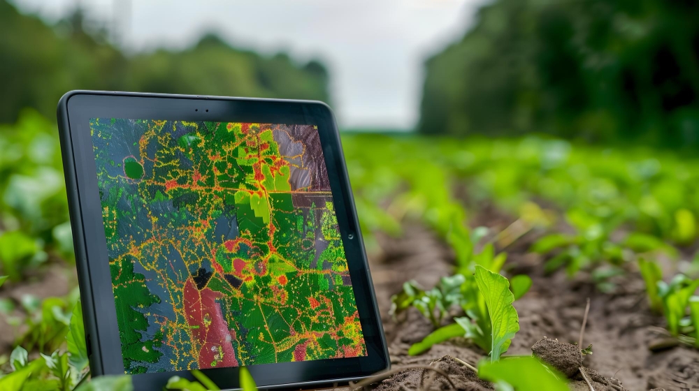
Precision agriculture mapping is the process of collecting detailed spatial data about farmland to help farmers manage crops more efficiently. Using drones equipped with cameras and sensors, large fields can be mapped to reveal crop health, soil conditions, irrigation patterns, and productivity variations.
Unlike traditional farming methods that treat an entire field uniformly, precision agriculture focuses on site-specific management. This means applying water, fertilizers, or pesticides only where they are needed rather than across the entire farm.
Drones play a critical role in this process by capturing high-resolution aerial imagery and generating maps that highlight variations within fields. These maps can reveal issues such as nutrient deficiencies, pest infestations, water stress, or soil variability long before they become visible to the human eye.
The result is smarter decision-making that improves crop productivity while reducing resource waste.
Why Precision Agriculture Mapping Is Becoming Essential
Modern agriculture faces increasing pressure. Farmers must produce more food while managing limited resources such as water, fertilizers, and arable land.
Precision agriculture mapping helps address these challenges by providing data-driven insights that improve efficiency and sustainability.
Early Detection of Crop Stress
Drone sensors and vegetation indices such as NDVI allow farmers to detect plant stress weeks before visible symptoms appear. Early detection enables farmers to intervene quickly and prevent yield loss.
Optimized Resource Management
Drone maps reveal differences in soil moisture, nutrients, and crop growth patterns across a field. Farmers can then apply fertilizers, pesticides, and water precisely where needed, reducing waste and improving crop health.
Higher Yields and Reduced Costs
Studies and field implementations show that precision agriculture technologies can reduce input costs while increasing crop yields due to targeted interventions and improved field monitoring.
Faster Field Monitoring
Drones can survey large farms quickly, covering hundreds of acres in a single day—far faster than manual field inspections.
These benefits explain why precision agriculture mapping is becoming a cornerstone of modern agricultural practices worldwide.
The Data Challenge in Precision Agriculture
Despite its advantages, precision agriculture depends heavily on high-quality geospatial data.
Organizations often face several challenges when trying to access agricultural drone datasets:
-
Hiring certified drone pilots for surveys
-
Conducting frequent drone flights across multiple regions
-
Processing large volumes of aerial imagery
-
Managing complex geospatial data pipelines
Meanwhile, drone operators around the world are generating thousands of agricultural datasets during field surveys, research projects, and mapping assignments.
After these projects are completed, much of this data remains archived and unused even though it could provide significant value for researchers, agritech companies, and agricultural analysts.
This disconnect between data creators and data users has created the need for a centralized platform where drone mapping datasets can be exchanged.
Drone Map Market: Connecting Drone Data Buyers and Sellers
Drone Map Market was designed to address this gap in the drone ecosystem.
Developed by GISFY, the platform functions as a drone data marketplace, where aerial mapping datasets can be shared, discovered, and accessed by professionals across industries.
Instead of every organization collecting new drone data from scratch, they can access existing datasets from drone operators around the world.
The platform enables two key user groups to interact:
Drone Data Sellers
Drone pilots, survey companies, and mapping professionals can upload drone datasets to the platform. These datasets may include agricultural maps, orthomosaics, multispectral imagery, and crop monitoring data.
By listing their data on Drone Map Market, sellers can monetize datasets that would otherwise remain unused.
Drone Data Buyers
Agriculture companies, agritech startups, research institutions, and analysts can browse and access drone mapping datasets relevant to their projects.
This helps organizations save time, reduce operational costs, and accelerate data analysis.
Drone Map Market essentially acts as a digital bridge between drone data creators and organizations that need geospatial intelligence.
Why Precision Agriculture Data Fits Perfectly in a Drone Data Marketplace
Precision agriculture mapping produces highly valuable datasets that can be used beyond a single farming project.
These datasets can support multiple applications, including:
-
Crop health monitoring
-
Irrigation planning
-
Soil variability analysis
-
Yield prediction models
-
Agricultural research and development
-
Climate and environmental studies
For example, an agritech company developing AI-based crop monitoring software may need large volumes of agricultural imagery to train machine learning models.
Instead of conducting drone flights across multiple farms, they can access ready-to-use datasets through Drone Map Market.
Similarly, agricultural researchers can analyze historical drone imagery to study crop growth patterns and environmental impacts over time.
This ability to reuse and share drone data across industries significantly increases the value of agricultural mapping datasets.
The Future of Precision Agriculture Mapping
The future of agriculture will be increasingly driven by data, automation, and artificial intelligence.
Drone mapping will continue to evolve with technologies such as:
-
AI-powered crop disease detection
-
Automated NDVI analysis
-
Predictive yield modeling
-
Integration with smart farm equipment
-
Real-time farm analytics platforms
But these technologies depend heavily on large volumes of high-quality drone data.
As the drone industry shifts toward a data-centric ecosystem, platforms like Drone Map Market will play a crucial role in enabling global access to geospatial intelligence.
Drone data marketplaces allow agricultural professionals to move beyond isolated datasets and build a collaborative ecosystem where data can be shared, analyzed, and reused.
Why You Should Register on Drone Map Market
If you are involved in drone mapping, agriculture analytics, or geospatial technology, joining a drone data marketplace can unlock significant opportunities.
For Drone Data Sellers
-
Monetize agricultural drone datasets
-
Reach a global audience of data buyers
-
Showcase your drone mapping capabilities
For Drone Data Buyers
-
Access precision agriculture mapping datasets instantly
-
Reduce the cost of conducting drone surveys
-
Accelerate research and analytics projects
By connecting both sides of the drone ecosystem, Drone Map Market is helping create a global network for drone mapping intelligence.
Join the Drone Map Market Ecosystem
Drone surveying has already transformed how industries collect spatial data. But the next evolution of this technology lies in how that data is shared and utilized.
By connecting drone data sellers with data buyers, Drone Map Market is building a global ecosystem where drone mapping datasets can create value far beyond their original projects.
Whether you are:
-
a drone pilot with valuable mapping data, or
-
an organization searching for high-quality drone survey datasets,
Drone Map Market provides a platform where geospatial data meets opportunity.
Register today: https://www.dronemapmarket.com/register/buyer
and become part of the growing global network where drone surveying data powers smarter decisions across industries. 🚁📊
